
Gesamtpreis (1 Artikel Artikel):
Versandziel:

engraved archer (24 Ergebnisse)
Direkt zu den wichtigsten Suchergebnissen
Suchfilter
Produktart
- Alle Product Types
- Bücher (12)
- Magazine & Zeitschriften (Keine weiteren Ergebnisse entsprechen dieser Verfeinerung)
- Comics (Keine weiteren Ergebnisse entsprechen dieser Verfeinerung)
- Noten (Keine weiteren Ergebnisse entsprechen dieser Verfeinerung)
- Kunst, Grafik & Poster (4)
- Fotografien (Keine weiteren Ergebnisse entsprechen dieser Verfeinerung)
- Karten (8)
- Manuskripte & Papierantiquitäten (Keine weiteren Ergebnisse entsprechen dieser Verfeinerung)
Zustand Mehr dazu
- Neu (Keine weiteren Ergebnisse entsprechen dieser Verfeinerung)
- Wie Neu, Sehr Gut oder Gut Bis Sehr Gut (Keine weiteren Ergebnisse entsprechen dieser Verfeinerung)
- Gut oder Befriedigend (14)
- Ausreichend oder Schlecht (Keine weiteren Ergebnisse entsprechen dieser Verfeinerung)
- Wie beschrieben (10)
Einband
- alle Einbände
- Hardcover (Keine weiteren Ergebnisse entsprechen dieser Verfeinerung)
- Softcover (Keine weiteren Ergebnisse entsprechen dieser Verfeinerung)
Weitere Eigenschaften
- Erstausgabe (Keine weiteren Ergebnisse entsprechen dieser Verfeinerung)
- Signiert (Keine weiteren Ergebnisse entsprechen dieser Verfeinerung)
- Schutzumschlag (Keine weiteren Ergebnisse entsprechen dieser Verfeinerung)
- Angebotsfoto (18)
- Keine Print-on-Demand Angebote (24)
Sprache (2)
Gratisversand
- Kostenloser Versand nach USA (Keine weiteren Ergebnisse entsprechen dieser Verfeinerung)
Land des Verkäufers
Verkäuferbewertung
-

Wells Cathedral. Entrance to the Crypt.
Erscheinungsdatum: 1835
Anbieter: theoldmapman, Clevedon, SOMER, Vereinigtes Königreich
Verkäuferbewertung 5 von 5 Sternen

Kunst / Grafik / Poster
EUR 4,78
EUR 7,54 Versand
Versand von Vereinigtes Königreich nach USAAnzahl: 1 verfügbar
In den WarenkorbSingle print. Original antique engraving for Winkles Cathedrals. 17 x 27 cm.
-

Wells Cathedral. Entrance to the Crypt.
Verlag: c1840 or later., 1840
Anbieter: theoldmapman, Clevedon, SOMER, Vereinigtes Königreich
Verkäuferbewertung 5 von 5 Sternen
Kunst / Grafik / Poster
EUR 10,75
EUR 7,54 Versand
Versand von Vereinigtes Königreich nach USAAnzahl: 1 verfügbar
In den WarenkorbSingle print. Original antique hand coloured engraving for Winkles Cathedrals. 17.5 x 24 cm.
-

Westmoreland
Erscheinungsdatum: 1835
Anbieter: theoldmapman, Clevedon, SOMER, Vereinigtes Königreich
Verkäuferbewertung 5 von 5 Sternen
Karte
EUR 8,36
EUR 7,54 Versand
Versand von Vereinigtes Königreich nach USAAnzahl: 1 verfügbar
In den WarenkorbSingle sheet. Original antique uncoloured engraved map. Centrefold as issued. Early copy without railways. 23.5 x 18 cm.
-

Radnorshire
Erscheinungsdatum: 1850
Anbieter: theoldmapman, Clevedon, SOMER, Vereinigtes Königreich
Verkäuferbewertung 5 von 5 Sternen
Karte
EUR 9,55
EUR 7,54 Versand
Versand von Vereinigtes Königreich nach USAAnzahl: 1 verfügbar
In den WarenkorbSingle sheet. Very fine original outline hand colouring of the County and Hundred boundaries as well as the railways which are a feature of these attractive maps. Centrefold as issued. 23 x 18 cm.
-

Salisbury Cathedral: View from South to North Transept.
Erscheinungsdatum: 1841
Anbieter: theoldmapman, Clevedon, SOMER, Vereinigtes Königreich
Verkäuferbewertung 5 von 5 Sternen
Kunst / Grafik / Poster
EUR 11,94
EUR 7,54 Versand
Versand von Vereinigtes Königreich nach USAAnzahl: 1 verfügbar
In den WarenkorbHand coloured antique steel engraving of the interior of the cathedral with figures including a verger with a child. 16 x 13cm mount window; 26.5 x 23.5cm overall in classic Hogarth frame. A little dusty inside the glass. Frame a little bumped at the corners. 26.5 x 23.5 cm.
-

Surrey. Swallows in the Banks of the River Mole, near Burford Bridge.
Erscheinungsdatum: 1840
Anbieter: theoldmapman, Clevedon, SOMER, Vereinigtes Königreich
Verkäuferbewertung 5 von 5 Sternen
Kunst / Grafik / Poster
EUR 16,72
EUR 7,54 Versand
Versand von Vereinigtes Königreich nach USAAnzahl: 1 verfügbar
In den WarenkorbSingle sheet. An antique hand coloured etching of the river where it passes near Box Hill. Engraved surface 175 by 115 mm; overall 220 x 175 mm. 22 x 17.5 cm.
-
MAP OF NOTTINGHAMSHIRE
Verlag: CIRCA 1845, 1845
Anbieter: Elder Books, Ross on Wye, Herefordshire, Vereinigtes Königreich
Verkäuferbewertung 5 von 5 Sternen
Karte
EUR 17,91
EUR 13,85 Versand
Versand von Vereinigtes Königreich nach USAAnzahl: 1 verfügbar
In den WarenkorbNo Binding. Zustand: Very Good. AN ORIGINAL MID 19th CENTURY MAP WITH EARLY HAND COLOUR, MEASURES APPROX 10.5 X 8.5 INCHES WITH MARGINS, BLANK REVERSE TO MAP, CARD MOUNT IN IMAGES IS FOR DISPLAY PURPOSES ONLY & DOES NOT COME WITH THE MAP. CENTRE FOLD TO MAP AS PUBLISHED, FEW MINOR MARKS TO MARGINS, OVERALL IN VERY GOOD CONDITION. EXTRA POSTAGE COSTS MAY APPLY TO OVERSEAS ORDERS. ALL ITEMS POSTED IN STURDY BOX.
-

Asia - Antiquarian Coloured Map
Sprache: Englisch
Verlag: Collins, London
Anbieter: K Books Ltd ABA ILAB, York, YORKS, Vereinigtes Königreich
Verbandsmitglied: ABA ILAB PBFA
Verkäuferbewertung 5 von 5 Sternen
EUR 29,85
EUR 22,61 Versand
Versand von Vereinigtes Königreich nach USAAnzahl: 1 verfügbar
In den WarenkorbNo Binding. Zustand: Very Good. Engraved & Drawn By J Archer (illustrator). An original antique map of Asia, printed ca. 1840. Mounted and ready to frame. Contemporary colouring in outline. In excellent condition, decorative and impressive. A clear map showing the main Empires & Countries of Asia from the Mediterranean to Japan.
-
MAP OF OXFORDSHIRE
Verlag: CIRCA 1845, 1845
Anbieter: Elder Books, Ross on Wye, Herefordshire, Vereinigtes Königreich
Verkäuferbewertung 5 von 5 Sternen
Karte
EUR 21,49
EUR 13,85 Versand
Versand von Vereinigtes Königreich nach USAAnzahl: 1 verfügbar
In den WarenkorbNo Binding. Zustand: Very Good. AN ORIGINAL MID 19th CENTURY MAP WITH EARLY HAND COLOUR, MEASURES APPROX 10.5 X 8.5 INCHES WITH MARGINS, BLANK REVERSE TO MAP, CARD MOUNT IN IMAGES IS FOR DISPLAY PURPOSES ONLY & DOES NOT COME WITH THE MAP. CENTRE FOLD TO MAP AS PUBLISHED, FEW MINOR MARKS TO MARGINS, OVERALL IN VERY GOOD CONDITION. EXTRA POSTAGE COSTS MAY APPLY TO OVERSEAS ORDERS. ALL ITEMS POSTED IN STURDY BOX.
-
MAP OF BUCKINGHAMSHIRE
Verlag: CIRCA 1850, 1850
Anbieter: Elder Books, Ross on Wye, Herefordshire, Vereinigtes Königreich
Verkäuferbewertung 5 von 5 Sternen
Karte
EUR 23,88
EUR 13,85 Versand
Versand von Vereinigtes Königreich nach USAAnzahl: 1 verfügbar
In den WarenkorbNo Binding. Zustand: Very Good. AN ORIGINAL MID 19th CENTURY MAP WITH EARLY HAND COLOURING, MEASURES APPROX 10.5 X 9 INCHES WITH MARGINS, BLANK REVERSE TO MAP. CENTRE FOLD TO MAP AS PUBLISHED, VERY MINOR MARKS TO MARGINS. OVERALL IN VERY GOOD CONDITION. EXTRA POSTAGE COSTS MAY APPLY TO OVERSEAS ORDERS. ALL ITEMS POSTED IN STURDY BOX.
-
Archer, rev. Thomas - of London - an Original Antique Portrait
Sprache: Englisch
Anbieter: K Books Ltd ABA ILAB, York, YORKS, Vereinigtes Königreich
Verbandsmitglied: ABA ILAB PBFA
Verkäuferbewertung 5 von 5 Sternen
EUR 29,85
EUR 22,61 Versand
Versand von Vereinigtes Königreich nach USAAnzahl: 1 verfügbar
In den WarenkorbNo Binding. Zustand: Very Good. A splendid antique engraved portrait, circa 1830. Mounted/matted and ready to frame. Attractive and decorative.
-
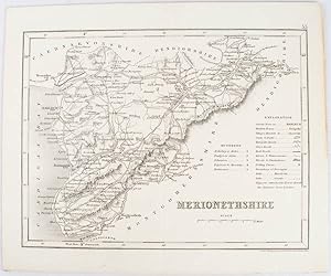
Map of Merionethshire
Verlag: L. Tallis. [1845]., London., 1845
Anbieter: Asia Bookroom ANZAAB/ILAB, Canberra, ACT, Australien
Verkäuferbewertung 5 von 5 Sternen
A black and white antique steel engraved map approx 23 x 18cm from "Curiosities of Great Britain. England & Wales"; by Thomas Dugdale, Assisted by William Burnett.
-
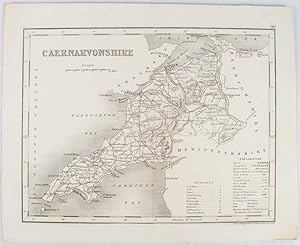
Map of Caernarvonshire.
Verlag: [c1845]., London., 1845
Anbieter: Asia Bookroom ANZAAB/ILAB, Canberra, ACT, Australien
Verkäuferbewertung 5 von 5 Sternen
A black & white antique steel engraved folding map approx 23 x 18cm from "Curiosities of Great Britain. England & Wales"; by Thomas Dugdale, Assisted by William Burnett. Published by L. Tallis, London.
-
Louis-Philippe, King of the French (1773-1850) - An Original Engraved Antique Portrait
Sprache: Englisch
Anbieter: K Books Ltd ABA ILAB, York, YORKS, Vereinigtes Königreich
Verbandsmitglied: ABA ILAB PBFA
Verkäuferbewertung 5 von 5 Sternen
EUR 35,82
EUR 22,61 Versand
Versand von Vereinigtes Königreich nach USAAnzahl: 1 verfügbar
In den WarenkorbNo Binding. Zustand: Very Good. Engraved By Archer (illustrator). A fine original steel engraving with elabprate decorative border. Mounted and ready to frame, this is a wonderful opportunity to purchase this splendid portrait.
-
Shee, M. A. - An Original Antique Portrait
Sprache: Englisch
Verlag: Cadell & Davies, London, 1811
Anbieter: K Books Ltd ABA ILAB, York, YORKS, Vereinigtes Königreich
Verbandsmitglied: ABA ILAB PBFA
Verkäuferbewertung 5 von 5 Sternen
EUR 59,70
EUR 22,61 Versand
Versand von Vereinigtes Königreich nach USAAnzahl: 1 verfügbar
In den WarenkorbNo Binding. Zustand: Very Good. A fine engraved portrait. Mounted/matted and ready to frame. Attractive, decorative and unusual.
-
MORTON, THOMAS, THE DRAMATIST - an Original Antique Engraved Portrait
Sprache: Englisch
Erscheinungsdatum: 1880
Anbieter: K Books Ltd ABA ILAB, York, YORKS, Vereinigtes Königreich
Verbandsmitglied: ABA ILAB PBFA
Verkäuferbewertung 5 von 5 Sternen
EUR 41,79
EUR 22,61 Versand
Versand von Vereinigtes Königreich nach USAAnzahl: 1 verfügbar
In den WarenkorbNo Binding. Zustand: Very Good. Sir Martin Archer Shee (illustrator). A suberb original antique engraving. Mounted - matted - and ready to frame . Very good condition . Printed c1880. An engraved portrait of Thomas Morton, the Dramatist, from the picture in the Vernon Gallery painted by Sir Martin Archer Shee, engraved by T W Hunt.
-
![Bild des Verkäufers für A Monochrome Map of Kent [Guide to Knowledge] zum Verkauf von Little Stour Books PBFA Member](https://pictures.abebooks.com/inventory/md/md1055345910.jpg)
A Monochrome Map of Kent [Guide to Knowledge]
Verlag: J. Archer, 100 Drummond Street, Euston Square, London . London 1833., 1833
Anbieter: Little Stour Books PBFA Member, Canterbury, Vereinigtes Königreich
Verbandsmitglied: PBFA
Verkäuferbewertung 5 von 5 Sternen
EUR 23,88
EUR 34,78 Versand
Versand von Vereinigtes Königreich nach USAAnzahl: 1 verfügbar
In den WarenkorbZustand: Very Good. Monochrome map of Kent measuring 7'' x 10''. From Guide to Knowledge No. LX. Price One Penny. In Very Good clean condition. Member of the P.B.F.A. KENT [Maps].
-
Shee, Martin Archer - Artist - from a Drawing By Jackson - an Original Antique Engraved Portrait
Sprache: Englisch
Erscheinungsdatum: 1817
Anbieter: K Books Ltd ABA ILAB, York, YORKS, Vereinigtes Königreich
Verbandsmitglied: ABA ILAB PBFA
Verkäuferbewertung 5 von 5 Sternen
EUR 47,76
EUR 22,61 Versand
Versand von Vereinigtes Königreich nach USAAnzahl: 1 verfügbar
In den WarenkorbNo Binding. Zustand: Very Good. Engraved By William Thomas Fry (illustrator). A splendid portrait, engraved by William Thomas Fry (1787-1835). Mounted/matted and ready to frame. Attractive and decorative.
-

ORIGINAL ENGRAVED MAP OF China Proper. (Asia, China, Qing Empire, Beijing, Peking, Hong Kong, Macao, Taiwan, Hainan). Qing Empire China Beijing Peking Hong Kong Macao
Verlag: Published by London by H. G. Collins. 1850, 1850
Anbieter: PROCTOR / THE ANTIQUE MAP & BOOKSHOP, DORCHESTER, Vereinigtes Königreich
Verbandsmitglied: PBFA
Verkäuferbewertung 5 von 5 Sternen
Karte
EUR 70,45
EUR 23,19 Versand
Versand von Vereinigtes Königreich nach USAAnzahl: 1 verfügbar
In den WarenkorbOverall size: 14 x 10.5 inches In very good condition. With published centre fold. A few faint foxing spots top margin.
-

A Coloured Map of Kent circa 1844
Verlag: J. Archer, Pentonville, London circa . London circa 1844., 1844
Anbieter: Little Stour Books PBFA Member, Canterbury, Vereinigtes Königreich
Verbandsmitglied: PBFA
Verkäuferbewertung 5 von 5 Sternen
EUR 59,70
EUR 34,78 Versand
Versand von Vereinigtes Königreich nach USAAnzahl: 1 verfügbar
In den WarenkorbZustand: Very Good. Coloured map of Kent measuring 9'' x 11''. Shows Railroad, Turnpike Roads, Stations, Polling Places. In Very Good clean condition. Member of the P.B.F.A. KENT [Maps].
-
![Bild des Verkäufers für A Hand-Coloured Map of Kent [1] zum Verkauf von Little Stour Books PBFA Member](https://pictures.abebooks.com/inventory/md/md1055345892.jpg)
A Hand-Coloured Map of Kent [1]
Verlag: J. Archer, Pentonville, London . London 1848., 1848
Anbieter: Little Stour Books PBFA Member, Canterbury, Vereinigtes Königreich
Verbandsmitglied: PBFA
Verkäuferbewertung 5 von 5 Sternen
EUR 89,56
EUR 34,78 Versand
Versand von Vereinigtes Königreich nach USAAnzahl: 1 verfügbar
In den WarenkorbZustand: Very Good. Hand-coloured map of Kent measuring 10'' x 8''. In Very Good clean and bright condition. Member of the P.B.F.A. KENT [Maps].
-
![Bild des Verkäufers für A Hand-Coloured Map of Kent [2] zum Verkauf von Little Stour Books PBFA Member](https://pictures.abebooks.com/inventory/md/md1055345893.jpg)
A Hand-Coloured Map of Kent [2]
Verlag: J. Archer, Pentonville, London . London 1848., 1848
Anbieter: Little Stour Books PBFA Member, Canterbury, Vereinigtes Königreich
Verbandsmitglied: PBFA
Verkäuferbewertung 5 von 5 Sternen
EUR 89,56
EUR 34,78 Versand
Versand von Vereinigtes Königreich nach USAAnzahl: 1 verfügbar
In den WarenkorbZustand: Very Good. Hand-coloured map of Kent measuring 10'' x 8''. In Very Good clean and bright condition. Member of the P.B.F.A. KENT [Maps].
-
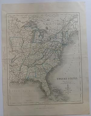
United States
Verlag: H. C. Collins 1840's, London, 1840
Anbieter: Peninsula Books, Traverse City, MI, USA
Verkäuferbewertung 5 von 5 Sternen
Karte
Map. Zustand: Very Good. A single sheet from an atlas, folded as issued, measuring 9" x 11.25". This map shows the eastern United States, including portions of Canada and one tier of states west of the Mississippi River including a small portion of "Texas." Hand-colored outlines of states are in blue and yellow. It also shows "railroads already open" in addition to cities, towns and geographical features. Also mentioned are locations of Sioux, Fox, Chippewa and Algonquin Indian tribes in the Midwest and Great Lakes region. Michigan is represented in the style of maps from 1820's-1840's, but the two railroads in the state are shown as completed and the state is correctly configured with the upper peninsula as well as the Ohio boundary (the Upper Peninsula is designated "Part of Michigan"). The capitol of Arkansas is designated as the ficticious Arkopolis. There is no date on this map, and I can't locate it in Karpinsk, but it is obviously taken from an atlas. "Paris" in pencil on blank verso of map in an old, ornate hand. Along the edge of the map is a comparison of distances in the United States and Great Britain with an 1830 date. Drawn and engraved by J. Archer, Pentonville, London and Published by H. G. Collins (22 Paternoster Row, London). While this is undated, it is probably from an 1840's edition of one of Gilbert's Atlases. Ref: Phillip's Maps in the Library of Congress, p. 603 ; Handcolored map; 9" x 11.25".


